


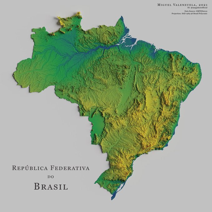
The map, titled “Topography of Brasil,” showcases Brazil’s diverse terrain with an artistic flair. Miguel Valenzuela’s work, highlighted in the post, uses a color palette that not only represents elevation changes but also subtly nods to the national flag of Brazil. Here’s a breakdown of what the map reveals:
Color Coding: The map employs a gradient from green to yellow to indicate elevation. The lush, lower-lying areas, particularly in the Amazon Basin, are depicted in various shades of green, signifying the dense forest coverage and lower altitudes. The transition to yellow and brown hues represents the rising elevations of the Brazilian Highlands, which dominate the eastern, southern, and central parts of the country.
Detail and Precision: Valenzuela’s map is not just aesthetically pleasing but also scientifically precise. It captures the intricate details of Brazil’s topography, from the flat expanses of the Pantanal, the world’s largest tropical wetland, to the rugged peaks of the Serra do Mar and Serra da Mantiqueira mountain ranges.
Artistic Touch: The map was created in 2021, as noted in the corner, showing Valenzuela’s signature style. His work often explores narratives of the border region, but here, he turns his artistic eye towards the expansive landscapes of Brazil, offering viewers a new perspective on a familiar geography.
The Context: Brazil’s Environmental Narrative
Brazil’s topography isn’t just a study of physical geography; it’s intertwined with the country’s environmental story, particularly concerning deforestation and climate change.
Deforestation: Recent studies have highlighted the alarming rate of deforestation in Brazil. According to Global Forest Watch, in the year 2020 alone, Brazil lost 2.73 million hectares of natural forest, contributing significantly to global CO₂ emissions. This loss of forest cover not only alters the topography but also the ecological balance of the region.
Climate Change Impact: The relationship between deforestation and climate change in Brazil is profound. A 2022 study mentioned by climate scientist Carlos Nobre indicates that 28% of Brazil’s agricultural land is no longer climatically optimal due to these changes. This shift impacts not only the agricultural sector, which relies heavily on stable climate conditions but also the topography as land use changes.
National Symbolism: Interestingly, the map’s color scheme resonates with the Brazilian flag, which features green and yellow prominently. The flag’s design, adopted in 1889, reflects the country’s heritage and aspirations, with the green representing the House of Braganza and yellow the House of Habsburg, symbolizing Brazil’s imperial past. The map’s colors, therefore, do more than just depict elevation; they evoke a sense of national identit

How do I buy the map?
Dm me on X @theepicmap