

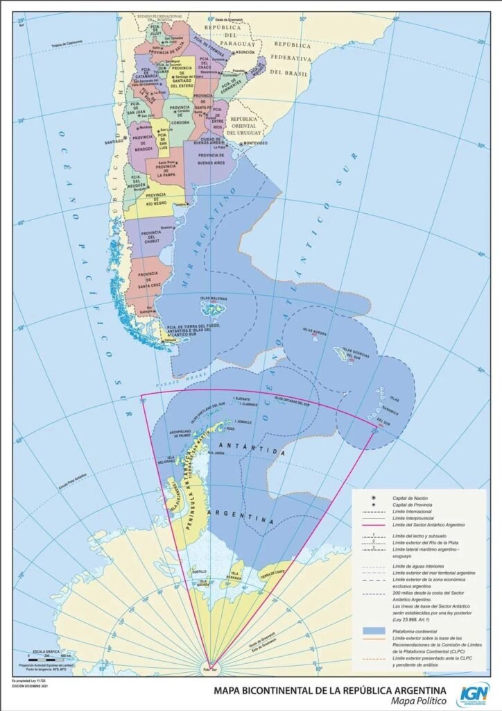
The map shared by is an official representation from the Instituto Geográfico Nacional (IGN) of Argentina. It presents the country’s extensive territorial claims, which extend far beyond its mainland:
Falkland Islands (Islas Malvinas): The map includes the Falklands within Argentina’s boundaries, a point of contention since 1833 when the UK established its presence. The dispute over these islands has been a significant issue in Argentina-UK relations, leading to the Falklands War in 1982.
Antarctic Territory: Argentina claims a sector of Antarctica, known as Argentine Antarctica, which overlaps with claims by the UK (British Antarctic Territory) and Chile (Antártica Chilena Province). This claim is regulated by the Antarctic Treaty System, which sets aside sovereignty disputes for the sake of scientific cooperation.
South Georgia and the South Sandwich Islands: Also included in Argentina’s claim, these islands are currently under British administration. The dispute here is less highlighted but part of the broader narrative of post-colonial territorial assertions.
Historical Context and Sovereignty Disputes
Falkland Islands Dispute
The sovereignty over the Falkland Islands has been a longstanding issue since the British reasserted control in 1833. Argentina has maintained its claim, arguing historical rights based on earlier Spanish and Argentine presence in the region. The dispute escalated into the Falklands War, where Argentine forces launched Operation Rosario on April 2, 1982, leading to a 10-week conflict. Despite a British victory, the dispute remains unresolved in Argentine narratives, as seen in their official maps.
The 2013 referendum where 99.8% of Falkland Islanders voted to remain British was dismissed by Argentina, highlighting the ongoing tension. The British stance, supported by international law principles of self-determination, contrasts sharply with Argentina’s historical claim.
Antarctic Claims
Argentina’s Antarctic claim stretches from 25°W to 74°W longitude and from 60°S latitude to the South Pole. This claim was made in 1940, predating the Antarctic Treaty, which was signed in 1959 to suspend all territorial claims for peaceful scientific research. The treaty’s success lies in its ability to manage these overlapping claims without resolving them, allowing for international cooperation in one of the Earth’s last frontiers.
The Geopolitical Implications
National Identity and Policy: The inclusion of disputed territories in Argentina’s official map is not merely cartographic but a statement of national identity and policy. It reflects Argentina’s commitment to these claims, impacting domestic politics and international diplomacy.
International Relations: The map’s depiction influences Argentina’s relations with the UK and other nations with Antarctic interests. Diplomatic efforts, like those at the United Nations, show how these claims are part of broader geopolitical strategies.
Legal Frameworks: The Antarctic Treaty and international law play crucial roles in managing these disputes. While the treaty focuses on peace and science, Argentina’s constitution explicitly includes these claims, indicating a legal stance that might challenge the treaty’s framework in future discussions.
Public Perception and Commentary
The X post and its thread illustrate the public’s engagement with these territorial issues:
@cityaestheticss
comments on Argentina’s tendency to claim territories it does not control, reflecting skepticism or criticism.
@GemsOfStat
shifts focus to Argentina’s educational achievements, perhaps to balance the narrative or highlight national progress in other areas.
@rakeshkaliya02
humorously suggests alternative ownership for the Falklands, showcasing how these disputes enter popular discourse.
@KhabrilalOG
provides geographical insights, while
@X__DataWorld
shares demographic data, adding layers to the discussion beyond just territorial disputes.
Conclusion
Argentina’s official map, as presented on X, is a vivid illustration of the country’s territorial ambitions, rooted in history yet alive in contemporary geopolitics. It serves as a reminder of unresolved disputes that continue to shape international law, diplomacy, and national identity. While the Antarctic Treaty provides a temporary peace by setting aside sovereignty issues, the Falklands remain a poignant symbol of post-colonial contention. As global dynamics evolve, these claims will likely continue to be a focal point in Argentine foreign policy, international negotiations, and public discourse.