
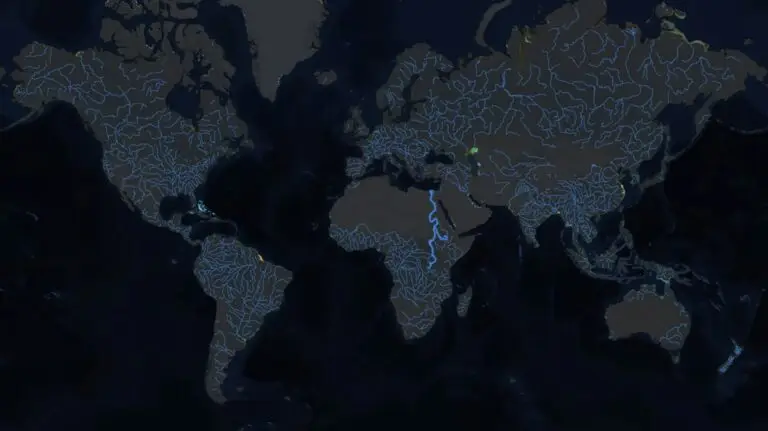
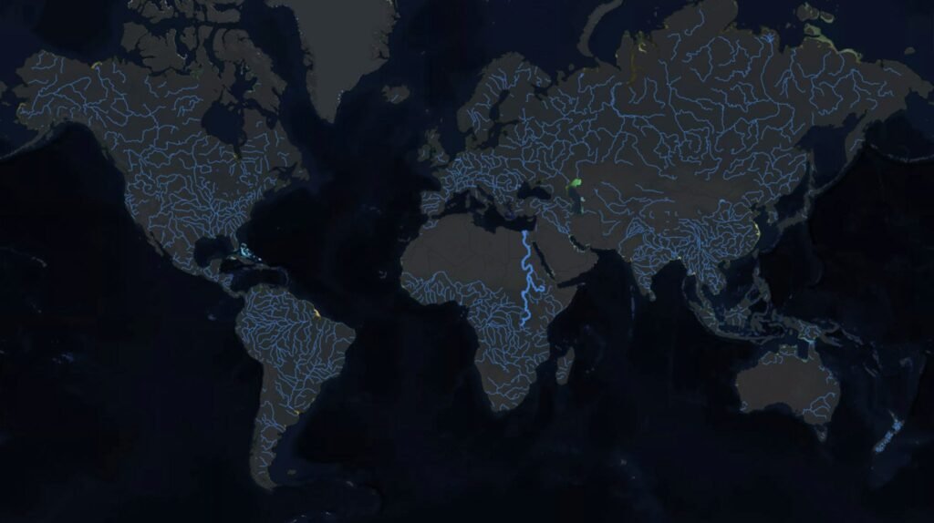
The map showcases a dark, almost night-like view of the world, with rivers illuminated in a striking blue, standing out against the backdrop. The focus of this map is the Nile River, which is vividly highlighted, drawing our eyes to its path from its sources to its mouth in the Mediterranean Sea.
The Nile and the Horse Latitudes
A key point of interest from the post by Epic Maps is the mention of the Nile crossing the Horse Latitudes. For those unfamiliar, the Horse Latitudes are subtropical regions around 30 to 35 degrees both north and south of the equator, known for their calm winds and high pressure, which historically posed significant challenges for sailing ships.
Why is this significant? These latitudes are typically dry due to the descending air that characterizes high-pressure systems, which makes it unusual for a river to maintain its flow through such an environment. The Nile, however, does exactly that, defying the typical arid conditions of these regions.
Crossing the Sahara
The Sahara Desert, one of the most formidable deserts on Earth, spans a vast area across North Africa. The map illustrates how the Nile cuts through this desert, providing a lifeline of water and fertility in an otherwise inhospitable environment.
The Nile’s Role: Historically, the Nile has been vital for the civilizations along its banks, most notably Ancient Egypt, which relied on the river for agriculture, transportation, and as a source of life. The river’s ability to cross the Sahara has made it a corridor for human settlement and cultural development.
Environmental and Hydrological Insights
Hydrology: The map does not only show the path of the Nile but also hints at the complex hydrological system that supports its flow. The river’s sources include Lake Victoria, Lake Tana, and various tributaries, which contribute to its volume as it traverses through multiple countries.
Environmental Impact: The presence of the Nile in the Sahara has significant environmental implications. It creates a unique ecosystem along its banks, contrasting sharply with the surrounding desert, supporting biodiversity and human life where it would otherwise be scarce.
Cultural and Historical Significance
The Nile is not just a geographical feature but a cultural and historical monument. From the ancient Egyptian civilization to modern-day nations like Egypt, Sudan, and Ethiopia, the river has shaped societies, economies, and even geopolitics.
Historical Context: The map’s depiction of the Nile’s path brings to mind the historical significance of the river, from the building of the Aswan High Dam in the mid-20th century to control its floods, to ancient practices of Nile flood prediction which were crucial for agriculture.
User Reactions
The X thread following the original post provides a rich tapestry of reactions, showcasing the global interest in this map:
Language and Culture: Christian
@christian__runs
noted the German term for Horse Latitudes, “Rossbreiten,” adding a linguistic and cultural dimension to the discussion.
Comparative Geography: Erhard
@ErhardSi
brought up the Mekong and the Rio de la Plata systems, comparing them with the Nile in terms of crossing significant geographical features, enriching the conversation with a broader geographical perspective.
Global Perspective: ピストル
@kuchipesu
expressed a sentiment from Japan, highlighting the local rivers not counted in such global discussions, which adds a layer of global inclusivity to the map’s narrative.
Conclusion
The map from Epic Maps 🗺️ serves as more than just a visual representation; it’s a gateway to understanding the complex interplay between geography, climate, culture, and history through the lens of the Nile River. This river’s journey across the Horse Latitudes and through the Sahara is a testament to its resilience and significance. As we continue to explore and map our world, such visual stories remind us of the natural wonders that have shaped human civilization.
Let’s keep our curiosity alive and continue to explore these wonders, one map at a time. If you’re as fascinated by this as I am, share your thoughts or any other interesting facts about the Nile in the comments below!
This detailed exploration into the map of the Nile River not only educates but also connects us with the global community intrigued by geographical marvels. Stay tuned for more such explorations in our future posts!