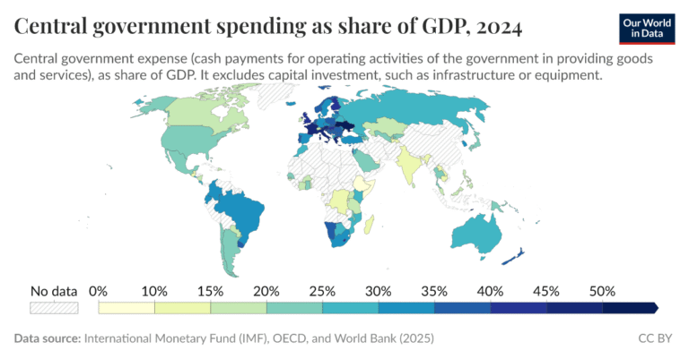
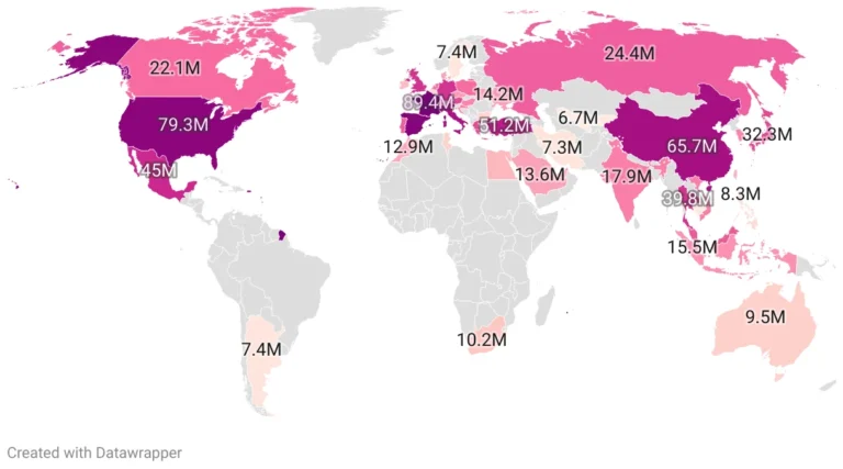
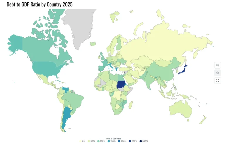
Category World

Map of America Before 1846-1848 Maxican American War

The map showcases the pre-war boundaries with Mexico in a vivid green, contrasting against the golden hues representing the United States of America. Key geographical features like the Pacific Ocean, Gulf of Mexico, and the Caribbean Sea frame the scene,…

Mythical Beasts of Italy

Welcome to a fantastical journey across the boot-shaped peninsula of Italy, not as you know it from the history books or travel guides, but through the lens of myth, legend, and folklore. The map titled “Mythical Beasts of Italy,” created…

Religion map of Germany

At first glance, the map is a vibrant display of colors, each representing a predominant religion or belief system within specific regions of Germany. Here’s a breakdown of what each color signifies: Blue shades represent areas where Catholicism is the…

France’s longest border is shared with Brazil

The map presents a comprehensive view of France’s borders, both in Europe and in South America, with a focus on the lengths of these borders in kilometers. Here’s a breakdown based on the visual data: France’s Borders in Europe:Belgium: 659…

The Official Map of Argentina

The map shared by is an official representation from the Instituto Geográfico Nacional (IGN) of Argentina. It presents the country’s extensive territorial claims, which extend far beyond its mainland: Falkland Islands (Islas Malvinas): The map includes the Falklands within Argentina’s…

Provinces of Argentina if named literally

The map in question, shared with the caption “Provinces of Argentina if named literally,” presents a fascinating twist on the traditional provincial names of Argentina. Here’s a breakdown of some of the notable renamings: Buenos Aires becomes Good Airs –…

Topography of Brasil

The map, titled “Topography of Brasil,” showcases Brazil’s diverse terrain with an artistic flair. Miguel Valenzuela’s work, highlighted in the post, uses a color palette that not only represents elevation changes but also subtly nods to the national flag of…

The Mississippi River and its tributaries

The map in question, which can be found here, presents a detailed depiction of the Mississippi River system. It showcases the river from its northern reaches, winding through the heartland of the United States, all the way down to its…

Topography of South America

The Map: A Visual MasterpieceThe map here provides a high-resolution depiction of South America, showcasing the continent’s topography in vivid detail. From the lush Amazon Basin to the arid stretches of the Atacama Desert, and from the sprawling grasslands of…