
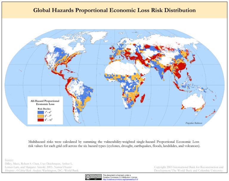
MAP OF NATURAL DISASTER RISK AND ECONOMIC LOSS IMPCAT
Natural disasters are unpredictable and impossible for humans to be safe of.
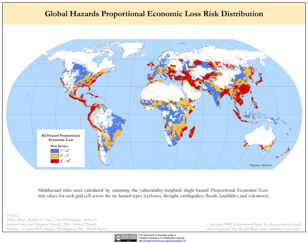
This map shows the economic loss risk distribution of global hazards by natural disasters. The given map is created with bringing 6 different natural disaster in our views. These disasters are Cyclones, Drought, Earthquakes, Floods, Landslides, and Volcanoes.
AFRICA
Most of African countries have less risk deciles. Africa’s highest risk zones are the northern and eastern coasts, the Horn of Africa, and a band down the east. These coastal nations, admired for their natural beauty and beaches, are highly exposed to cyclones, floods, and droughts, especially where economic activity clusters in low-lying urban centers near the shoreline. Inland regions generally show lower risk, except in parts affected by recurrent drought and flood cycles. Most of economic loss happen because of insufficient rain.
EUROPE
Europe’s risk is concentrated along the Mediterranean basin—specifically southern Spain, Italy, Greece, and Turkey’s coastlines. These areas, celebrated for their tourism appeal and cultural heritage sites, face exposure to floods, earthquakes, and landslides. Northern and Eastern Europe are generally less exposed, with most economic risk tied to severe weather and localized flooding. On West Europe, United Kingdom is also very exposed to Natural disasters.
NORTH AMERICA
North America’s greatest risks are seen in hurricane-prone coastal states: the Gulf of Mexico, Caribbean shores, and parts of the southeastern United States. Mexico’s Pacific and Caribbean coasts are also highly exposed. These regions, valued for their warm climates and tourist economies, are vulnerable to losses from cyclones, earthquakes, and flooding. The western US, including California, is marked by earthquake and wildfire risk, though interior regions generally show lower hazard-related economic losses.
SOUTH AMERICA
South America, particularly Chile and Peru, faces earthquake and tsunami risk, while Brazil’s coast is exposed to floods and landslides. These areas, rich in biodiversity and tourist attractions, are especially vulnerable due to the clustering of urban assets near the coastline. Other zones, such as the Amazon Basin, register lower risk except where seasonal flooding is recurrent.
ASIA
Asia has some of the most extensive high-risk zones, especially in low-lying, populous coastal areas. Bangladesh, eastern India, southern China, Vietnam, and the Philippines face significant multi-hazard risk due to cyclones, flooding, and earthquakes. These regions support dense populations and thriving tourism but are frequently disrupted by natural disasters, amplifying their economic vulnerability. Japan’s coastal cities also stand out as high-risk due to earthquake and typhoon exposure, despite their advanced preparedness measures. Other coastal Nations also face much economic loss due to its multi-Hazards risk for disasters.
OCEANIA
Australia’s eastern seaboard, including cities like Brisbane and Sydney, shows higher risk due to cyclones and floods, whereas the western and central regions show much lower risk. Oceania’s small island nations, though not always visible in map detail, are universally at high risk, given their exposure to cyclones and tsunamis. The picturesque beaches and coral atolls that attract tourists also place these nations at economic risk due to infrastructure vulnerability.
CONCLUSION
Most of those countries that have more natural beauty, those in the risky tectonic plates, have a more risk of economic loss by natural disasters.