
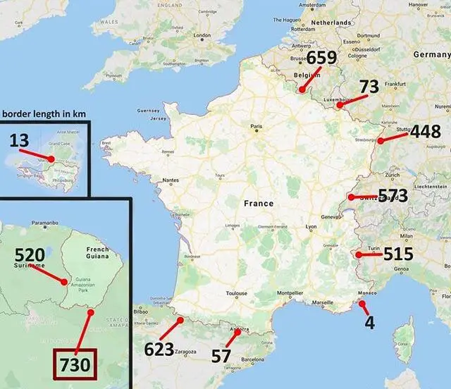
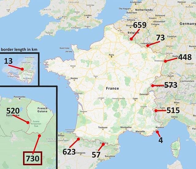
The map presents a comprehensive view of France’s borders, both in Europe and in South America, with a focus on the lengths of these borders in kilometers. Here’s a breakdown based on the visual data:
France’s Borders in Europe:
Belgium: 659 km
Luxembourg: 73 km
Germany: 448 km
Switzerland: 573 km
Italy: 515 km
Spain: 623 km
Andorra: 57 km
Monaco: 4 km
France’s Borders in South America (French Guiana):
Brazil: 730 km
Suriname: 520 km
Key Insights from the Map
Longest Border with Brazil:
The map clearly shows that the border between French Guiana and Brazil is the longest France shares with any country, totaling 730 kilometers. This is significant as it underscores France’s global territorial presence, extending beyond Europe into South America.
French Guiana’s Strategic Position:
Located on the northern coast of South America, French Guiana’s position between Brazil and Suriname is highlighted. This placement not only connects France to South America but also makes it a unique part of the European Union, with its borders directly adjacent to non-EU countries.
Comparison with European Borders:
While France shares substantial borders with European nations, the length of the Brazil-French Guiana border surpasses all of them, emphasizing the importance of overseas territories in understanding France’s geopolitical scope.
Environmental Context:
The map situates French Guiana within a region known for its dense Amazon rainforest, suggesting that this border is not just a political line but also an ecological one, crossing through one of the world’s most biodiverse areas.
Cultural and Political Implications:
The border with Brazil through French Guiana brings into focus the cultural and political diversity of France’s territories. French Guiana, being an integral part of France, introduces a blend of European governance with South American geography and culture.
Infrastructure and Connectivity:
Although not detailed on the map, the mention of the Oyapock River Bridge in related discussions (from web results) adds a practical dimension to this border. This bridge is the only one crossing the France-Brazil border, highlighting the connectivity and infrastructure development in this remote region.
Conclusion
The map from Epic Maps 🗺️ provides a visual representation that goes beyond mere statistics, offering a narrative of France’s expansive reach and the unique geopolitical landscape it navigates. The France-Brazil border, stretching over 730 kilometers through the lush Amazon, stands out as a testament to the complexities of modern statehood, where national borders can span continents, blending diverse ecosystems, cultures, and political systems. This analysis, based solely on the map, reveals how French Guiana’s position significantly alters our understanding of France’s global presence, making this border not just the longest but one of the most intriguing in terms of its implications for international relations, environmental conservation, and cultural exchange.