

Introduction to Japan’s Topography
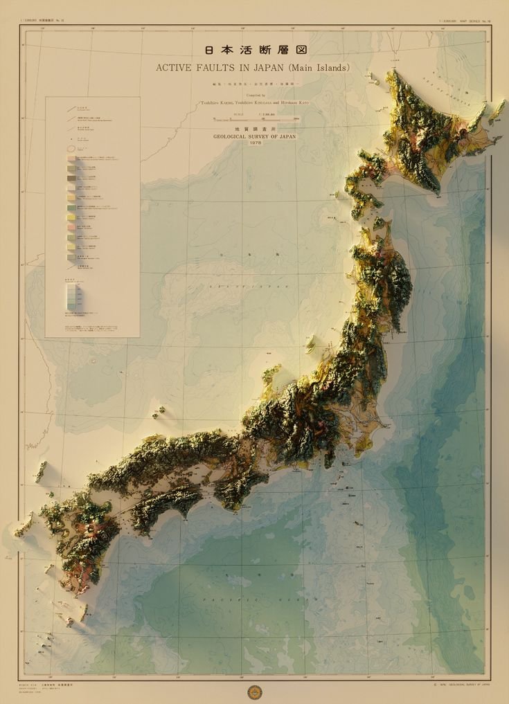
Japan, an archipelago nation in East Asia, is renowned for its stunning landscapes, from the snow-capped peaks of the Japanese Alps to the serene beauty of its coastal regions. The topographic map provided by Epic Maps gives us a bird’s eye view of this diversity, with elevations and depressions vividly illustrated. The map’s title, “Active Faults in Japan – Okinawa Islands,” immediately sets the tone for understanding not just the physical geography but also the geological dynamics at play.
Understanding the Map
The map is meticulously crafted to reflect the elevation changes across Japan, with colors and shading indicating various altitudes. Here’s what stands out:
Mountains and Highlands: The green and brown hues represent the mountainous regions, with Japan’s iconic mountain, Mount Fuji, likely being one of the prominent features, although not explicitly labeled on this map. The backbone of Japan, the Japanese Alps, stretches across the central part of Honshu, the main island.
Coastal Regions: The map shows the intricate coastline of Japan, with lighter shades representing lower elevations. This is crucial for visualizing the vulnerability of coastal areas to tsunamis, a common aftermath of seismic events.
Active Faults: Perhaps the most critical aspect of this map is the depiction of active faults. These are shown as lines cutting across the landscape, emphasizing the tectonic activity that shapes Japan’s geography. The presence of these faults is a reminder of Japan’s location on the Pacific Ring of Fire, where several tectonic plates converge, leading to frequent earthquakes.
Geological Significance
Seismic Activity: Japan experiences around 1,500 earthquakes every year, many of which are due to these active faults. The map helps in visualizing where these faults intersect with urban centers, which is vital for disaster preparedness and response strategies.
Volcanism: Linked to the faults are Japan’s numerous volcanoes. The map indirectly suggests areas where volcanic activity might be expected, given their association with fault lines.
Disaster Preparedness: Understanding the topography, especially the location of active faults, is integral to Japan’s advanced disaster management systems. This map can serve as an educational tool to explain why Japan has developed such robust early warning systems and infrastructure resilience.
Cultural and Historical Context
Historical Earthquakes: Japan’s history is dotted with significant seismic events, like the Great Hanshin earthquake in 1995 and the 2011 Tōhoku earthquake and tsunami. This map provides a visual context to these events, showing how geography played a role in their impact.
Cultural Impact: The rugged terrain and the constant threat of natural disasters have influenced Japanese culture, from architecture designed to withstand earthquakes to festivals celebrating resilience.
Modern Implications
Urban Planning: Modern cities in Japan are planned with these geological features in mind. The map illustrates why certain areas might be less developed or why there are specific zoning laws regarding construction.
Tourism: For tourists, understanding this map can enhance appreciation of Japan’s landscapes while also being aware of safety considerations, especially in regions prone to seismic activity.
Conclusion
The topographic map of Japan, focusing on its active faults, is more than just a geographical representation; it’s a narrative of a nation shaped by its geology. It underscores the importance of living in harmony with nature, respecting its power, and preparing for its unpredictability. For geographers, seismologists, urban planners, and the curious traveler, this map is a treasure trove of information, offering insights into how Japan’s land has shaped its people, history, and future.
As we continue to explore and understand our planet, maps like these from Epic Maps serve as critical tools in education, planning, and appreciation of natural landscapes. Japan’s story, as told through its topography and the silent lines of its faults, is one of resilience, beauty, and the perpetual dance with the forces of nature.
This detailed exploration of Japan’s topography, through the lens of its active faults, not only educates but also connects us to the land in a profound way, reminding us of the delicate balance between human habitation and the natural world.